Are you getting ready to sell rural acreage in Mills River and wondering what will truly move buyers to act? You are not alone. Land buyers in Western North Carolina want answers fast, especially around access, buildability, utilities, and visuals that show the land’s potential. In this guide, you will learn exactly how to present your property clearly and confidently so you attract serious buyers and shorten time to offer. Let’s dive in.
What buyers want in Mills River acreage
Mills River attracts acreage buyers who want privacy, views, and a practical path to building or recreation. When you prepare your listing, focus on what they care about most:
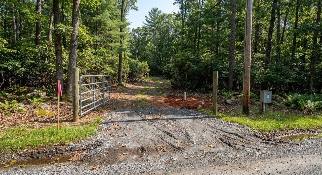
- Legal access with clear road frontage or a recorded easement and a drivable route.
- Usable acreage with realistic building sites and septic suitability.
- Topography and views that show how the land “lives.”
- Water features and any wetland limits that affect development.
- Utilities, including electric and internet, plus public water or private well needs.
- Proximity to Hendersonville, Asheville, and daily services.
- Any encumbrances like easements, rights of way, or conservation restrictions.
When your maps, notes, and photos address these points up front, buyers feel informed and ready to tour.
Nail the basics: boundaries and access
Accurate boundaries and proven access are the foundation of a strong land listing. Handle these first.
Documents to gather
Collect the key records so buyers and their attorneys can verify details right away:
- Recorded deed and legal description with metes and bounds or a plat reference.
- Most recent survey or boundary plat. If you do not have one, plan to commission one.
- Parcel ID and tax card for the current year.
- Recorded easements and road maintenance agreements.
- Any covenants, HOA rules, or conservation easements.
Maps that answer questions
Turn your documents into simple, readable visuals:
- Aerial map with the parcel boundary clearly outlined.
- Regional map showing proximity to Asheville, Hendersonville, and major roads.
- Road and driveway access map that labels whether the road is state maintained, county, or private.
- Topographic or slope map that highlights probable build sites and steep areas.
- Soils map inset that notes general septic suitability.
- Floodplain and wetland overlays so buyers can see buildable areas.
- Utility context showing visible service lines or nearby public water.
Always include a north arrow, scale bar, legend, data sources, and the date of imagery or survey. If you are using county parcel lines without a current survey, label parcel boundaries as approximate.
Where to pull authoritative data
Use official sources so you can stand behind your graphics and answers:
- Henderson County GIS and Parcel Viewer for parcel boundaries and tax IDs.
- Henderson County Register of Deeds for deeds, plats, and recorded easements.
- USDA NRCS Web Soil Survey for soils and septic limitations.
- FEMA Flood Map Service Center for flood zones and panel numbers.
- NC OneMap and North Carolina Department of Environmental Quality for statewide environmental layers, streams, and wetlands context.
- NCDOT for driveway permit guidance on state maintained roads.
- Henderson County Environmental Health for septic permits and perc testing.
- Town of Mills River for public works, water or sewer availability, and local ordinances.
- Local land trusts such as Conserving Carolina for conservation easement records.
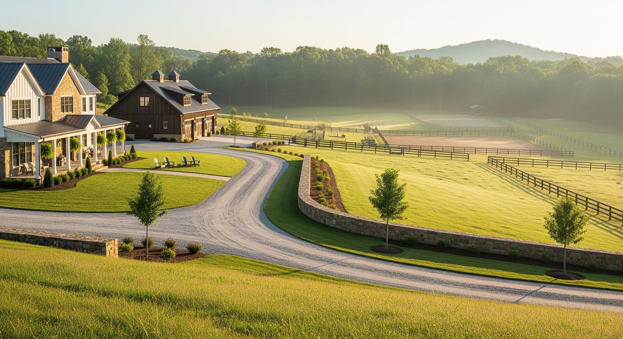
Show buildable potential with overlays
Clear overlays answer the biggest buyer questions in seconds. Use them to point out opportunities and constraints.
Floodplains and streams
Check FEMA maps and identify any portion of the property in a flood zone. If a floodplain exists, highlight buildable areas outside the zone. Label mapped streams and note where riparian buffers may apply. Desktop indicators are useful, but only a qualified professional can delineate wetlands or stream jurisdiction on site.
Soils, septic, and water
Use soils mapping to show general drainage classes and hydric soils. If prior septic permits or perc tests exist, disclose them. In areas without public water, note that a private well will be required. Buyers appreciate clarity on what is known and what still needs site evaluation.
Topography and slope
Slope shading and contour lines help buyers visualize grading, driveway options, and site prep costs. Mark potential building pads on gentler slopes and flag any steep sections where development is less practical.
Easements and legal access
Distinguish clearly between public road frontage, recorded deeded access, and shared private drives. Buyers often walk away if access is uncertain. If you are selling land that needs a new driveway tie in on a state road, note that a driveway permit from NCDOT may be required.
Zoning and permits
Confirm the zoning that applies through the Town of Mills River or Henderson County. Share basic setbacks, minimum lot size, or conditional use notes if relevant. Buyers also want to know the typical sequence for building, including driveway permits, septic and well approvals, erosion control measures, and building permits.
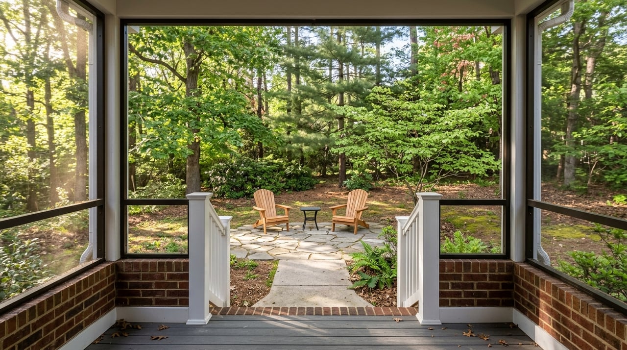
Photography that sells land
Strong visuals reduce showings from tire kickers and attract informed, motivated buyers. Aim for 30 to 60 high quality images plus 1 to 3 short aerial videos.
Ground photo checklist
Entry and road frontage with the road name visible.
Full length driveway shots to convey grade and approach.
Highest vantage point views with a simple panorama if possible.
Key features such as pastures, barns, fencing, gates, culverts, and ponds.
Ground conditions in potential build areas.
Utilities you can document, such as an electric meter or well head.
Context shots showing privacy and adjacent land uses from the property line.
A few scale shots that include a person or vehicle to show slope and size.
Drone and aerials: what to capture
- Orthogonal straight down frames with a parcel boundary overlay.
- Low obliques along boundary lines to reveal slope and tree cover.
- Approach footage that follows the road and driveway from above.
- Focused passes over building sites, water features, and notable landmarks.
- A short flyover video that traces a consistent path and labels key points.
Labeling and delivery
Export high resolution images suitable for web and print. Caption your photos with view direction and what the viewer is seeing. On aerial composites, include a clear legend, north arrow, scale, parcel boundary, access route, and a simple note like Buildable Area if you are confident in your mapping. State the month and year the images were taken so buyers understand seasonal differences.
Drone rules and safety in the AVL area
Aerial marketing is a great asset in Mills River, but it must be done responsibly and legally.
FAA Part 107 and Remote ID
Commercial listing photography requires an FAA Part 107 certified remote pilot. Confirm your operator’s certification, registration, and liability insurance. Ensure the drone complies with current Remote ID requirements.
Airspace and local terrain
Operations near Asheville Regional Airport require attention to controlled airspace. Your operator should check airspace and obtain any needed authorization. Mountain terrain and tree canopy can create wind shear and rapid line of sight loss, so plan conservative flight paths and maintain visual contact.
Privacy and insurance
Follow North Carolina privacy laws. Avoid shooting into neighboring homes or private areas. Work with an insured operator who can provide a certificate of insurance if needed.
Your pre listing sequence
Follow this step by step plan to get market ready.
- Gather deed, parcel ID, any existing survey or plat, and all recorded easements.
- Export the parcel from the Henderson County GIS to create boundary overlays.
- Run desktop checks for flood zones, soils, streams, and wetland indicators using FEMA, NRCS, and NC datasets.
- Verify legal access. If unclear, obtain a title opinion or recorded easement before listing.
- Order a boundary survey if one does not exist or if lines are in dispute. Start early since timing can vary.
- If septic suitability is unknown and central to pricing, schedule a soil evaluation with Henderson County Environmental Health.
- If wetlands or water features will be featured, hire a qualified professional to delineate them.
- Hire a Part 107 drone operator and schedule flights for optimal weather and seasonal conditions.
Deliverables buyers love
Prepare these items so your listing launches with authority.
- Parcel map with an aerial base and boundary overlay.
- High resolution aerial orthophoto labeled with access and potential building area.
- A complete photo gallery that covers access, views, build sites, utilities, and water features.
- A short aerial video flyover that highlights key points.
- A one page data sheet with parcel ID, acreage, road frontage, access type, estimated buildable acres, septic and well status, easements, and nearest services.
- Organized copies of the deed, plat, and any easements for due diligence.
Costs and timelines to plan for
Every property is different, but plan for these variables.
- Boundary survey costs vary with acreage, terrain, and complexity. Large or steep tracts take longer and cost more.
- Wetland delineation and soil testing are field based and priced by scope. Get estimates from local professionals.
- Drone photography and video packages typically cost a few hundred dollars. Confirm deliverables and licensing terms.
- Permit timing for driveway, septic, and building depends on agency review. Start early if your listing strategy includes pre listing improvements.
Avoid these common pitfalls
- Listing without clear legal access details.
- Relying only on tax parcel lines and not labeling them as approximate.
- Skipping slope and soils context, which fuels buyer uncertainty.
- Posting a thin photo set that hides access, scale, or terrain.
- Flying a drone without Part 107 credentials or airspace authorization.
- Choosing imagery that does not match the land’s best season of use.
Ready to sell smarter in Mills River?
If you want a smoother sale, focus on boundaries, access, buildability, and visuals that tell a clear story. When you pair accurate maps with honest, high quality ground and aerial imagery, you answer buyer questions up front and increase confidence in your pricing.
You do not have to do this alone. The Amy Team brings hands on preparation, local know how, and modern marketing to rural acreage sales in Mills River and across Western North Carolina. Reach out to schedule your free home valuation and talk strategy with a named agent today.
FAQs
What documents do I need to market Mills River acreage?
- Provide your recorded deed, the most recent survey or plat, parcel ID and tax card, and any recorded easements, covenants, or conservation restrictions.
How can I show legal access to my land listing?
- Map the frontage on a public road or include the recorded easement and label who maintains each road segment, then show the driveway route on an access map.
How do I prove my acreage is buildable?
- Combine a slope map with soils context and any septic evaluations, then highlight likely building areas outside flood zones and away from wetlands.
Do I need drone photos to sell land in Mills River?
- While not required, aerials help buyers understand boundaries, slope, and access quickly, which can reduce time to offer when done by a qualified operator.
What permits should I consider before listing?
- Common approvals include septic permits, well documentation or public water availability, NCDOT driveway permits for state roads, and standard building permits.
Who can help me get authoritative maps and overlays?
- Use Henderson County GIS for parcel data, the Register of Deeds for plats and easements, FEMA for flood zones, NRCS for soils, and NC OneMap and NCDEQ for environmental layers.